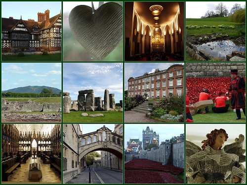
I invite you to read my reflection on 2014 on the Broad Oak Magazine blog.

I invite you to read my reflection on 2014 on the Broad Oak Magazine blog.
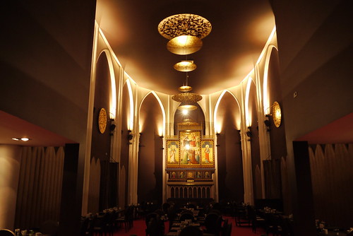
I invite you to read my post about the historic town of Mechelen on the Broad Oak Magazine blog.
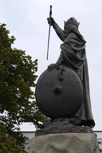
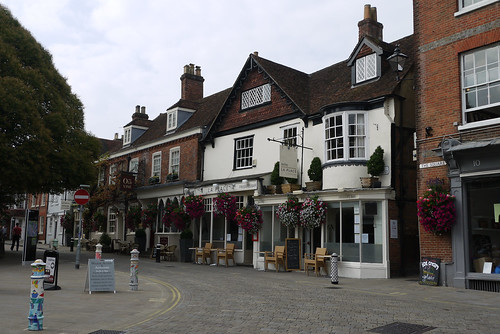
After our trips further afield from Winchester it was time to explore the historical town itself. We set off on a walking tour that was shown in the back of the ‘Winchester Pitkin Guide’. The first stop on route was to photograph the statue of King Alfred. It was good to find that the hanging basket that had been hung on his sword by weekend revelers had been removed, therefore allowing for a perfect photo opportunity.
As we walked along the route we noticed ‘The Church of St Lawrence‘. It was a hidden gem tucked away in among the shops. With the exception of the sounds of music from a street musician the noise and the hustle and bustle from outside could not be heard.
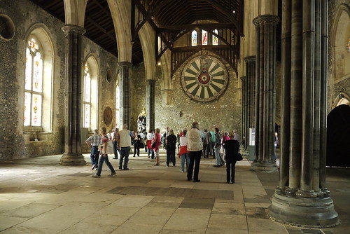
After experiencing solitude in the church we carried along the path of our walking route towards Westgate. Unfortunately the museum was closed, but I did get to see a lone man working on repair work on a nearby steeple. We carried on past the Westgate to the Great Hall. The hall and the round table have breathtaking proportions. My immediate thought on entering the hall was WOW!!!
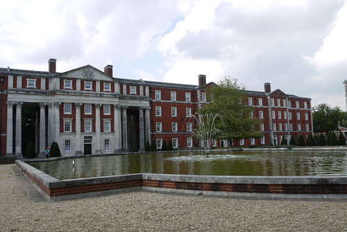
The next port of call was Peninsula Barracks to take in a couple of the museums that were on Mr C’s ‘To Do’ list. Before the museum visits we had lunch in Cafe Peninsula, where I opted for Crayfish sandwich, it was delicious. Mr C’s museum choices were HorsePower, the Museum of The King’s Royal Hussars and the Gurkha Museum.
Both museums were interesting to me. The HorsePower museum because of my interest in armoured vehicles, the development of ‘main battle tanks’, specifically Challenger 2. The Gurkha museum with its life sized and scale models of battle situations enabling the visitor to see the extreme difficulties that the Gurkhas overcame. Unusually after those two visits Mr C was all military museumed out…We continued on our walking route and visited St Swithun upon Kingsgate, a rare example of a church located above the historic gates of a city.
After all that walking we returned to the hotel to chill out and rest our weary feet before venturing out for our evening meal. Our venue for the evening was La Place, the food was excellent but unfortunately we were sitting next to a table whose occupants were a drunk and rowdy threesome. They were not happy drunk, there was a grumpy edginess to it. As they were sitting just behind me I felt really uncomfortable until they left. They were older people so I can’t even give them the benefit of being young and stupid.
Before returning to our hotel for a good nights sleep we retired to The Old Vyne to relax after the unpleasant experience.
It is my turn at Vision & Verb today. My post is about a project launched by the Imperial War Museum (IWM). It is a digital memorial to record the life of every person who served in uniform or worked on the home front during World War One. An ancestor of mine is listed on the site so I will be taking a small part in the project. I invite you to join me there.


The historic Iron Bridge within the grounds of Cragside was re-opened in 2009 for the first time in nearly 30 years. The 19th century bridge spans the Debdon Burn and until that time the grade II listed bridge had been closed due to safety concerns.
It is now possible for visitors to walk across the bridge, providing magnificent views of the house and rock garden along with views of the Debdon valley with its waterfalls.
The bridge was manufactured in the Elswick Works and transported in bits to Cragside where it was constructed in situ. The bridge was designed by the owner of the estate, Lord Armstrong, who wished to provide walking access from the house to the formal gardens.


… St Cuthbert’s Church


The Consistory Court Stalls were reconstructed in 1934 from fragments from the 14th centuray stalls in the choir left over after their rearrangement by Sir George Gilbert Scott in the 1860s.
They were used as seats for the bishop and his officers when holding church courts. The misericords, or carvings under the seats, are of 20th century workmanship except for the one on the right, which is 14th century and shows a wyvern (a mythical beast) with a snail on leaf.
The figures on the lectern represent the Virgin Mary and her mother Saint Anne. *
*From Cathedral information board.
 Synopsis (from book cover):
The Hereford mappa mundi is the largest an most elaborate world map surviving from before teh fifteenth century. Designed at Lincoln by one Richard of Holdingham, it was made for Hereford in about 1300 and Hereford has been its home ever since.
There has been much speculation as to the identity of the author of the map, and the purposes for which it might have been made. More than just a map, it can be seen as an encuuclopaedia of distant lands, their peoples, myths and natural history, all held to gether within a framework of Christian belief – the figure of Christ in judgement is placed in a prominent position at the top of the map. It presents an illuminating view of the world as it appeared to a cultured and will read person in theirteenth-century England.
In this book P. D. A. Harvey provides an authoritative introduction to the map, based on recent work, showing how it was made, what it depicts and what sources the author used. Many detailed photgraphs, specially commiddioned for the purpose, together with illustrations of othe related medieval maps, accompany the text.
Book Review:
I picked this book up in Hereford Cathedral, when I visited the Mappa Mundi. The book dated 2010 is an updated version of an earlier book that was first published in 1996. The book covers the most recent research and findings regarding the map.
The book covers the making of the map, the history of the map and sources of information for the content of the map. The book also sets the map into context with other similar world maps. The text is enhanced by many colour photographs showing the Hereford map and other world maps of this type.
I found the book very interesting and recommended it to anyone who is interested in the subject.

The Wellington Arch and its companion Marble Arch have interesting histories. The English Heritage guidebook introduction gives a brief overview:
Usually built to commemorate a great victory, the triumphal arch was a familiar feature of the Roman world. In the 1820s, this classical model was adapted by two of the finest architects on the day: Decimus Burton used it for the Wellington Arch, and John Nash copied the Arch of Constantine in Rome as the basis for the Marble Arch. This was no mere accident, since both arches were indeed mean to serve as victory monuments. After much public lobbying, Britain was at last to have appropriate memorials marking its military and naval triumphs over Napoleonic France.
The patron behind these works was King George IV, who had long been greatly interested in architecture. His vision was that of a grand ceremonial route into his newly planned metropolitan residence, Buckingham Palace. The Wellington Arch would serve as the outer entrance at the top of Constitution Hill, and the Marble Arch would open gloriously into the courtyard of the palace itself.
The guidebook goes onto explain the context for design and construction of each arch and also their turbulent later histories, including their complete removal to fresh sites in the Victorian era, through to the present day.


 …a medieval view of the world
Synopsis (from book cover):
How was it possible for such a large and fragile artifact to have survived intact from the Middle Ages to the present day? The Hereford Mappa Mundi, moved in April 1996 from the Cathedral Crypt to a purpose built museum, is an unique document. It provides us with a window into time past when there were no aeroplanes or cars, no radio or television, no telephones or newspapers and when travel beyond the immediate confines of ones’s home was an arduous and considerable undertaking. All the more remarkable therefore that such a map of the world is able to show relative positions for cities and whole continents, although the people and animals depicted are often bizarre and fantastical. The Mappa Mundi gives us today an incomparable insight into the mind of Medieval Christendom, depicting not only the geographical world but also the spirituality, philosophy of life and the political and economic structures of its people. The creation of such a map was not only a considerable achievement, but a symbol of power and status in a world still in a feudal stat. This volume takes the reader on a tour of that world as well as of the maps; a journey as fascinating as the Mappa itself.
Book Review:
When I visited Hereford Cathedral in November I particularly wanted to revisit the Mappa Mundi. I picked up this book whilst I was there.
The book gives added incite to the Mappa Mundi which is housed in a specially built display wing of the Cathedral. It is uncertain whether the Mappa was created in Hereford or elsewhere. This book takes the view that the map was created elsewhere and one of the topics is the map’s origins and journey to Hereford. Other topics include the medieval view of the world, the geography of the map and the creatures (both real and mythical) that feature on the map.
The book is illustrated throughout by Dominic Harbour, it also contains a full colour copy of the Mappa Mundi.
I recommend the book to anyone who wants to find out more about the Hereford Mappa Mundi.
